
6231 iii - AN THANH, Map - HCM Trail 1971 - Chiphu, Cambodia Border, Vietnam War For Sale

When you click on links to various merchants on this site and make a purchase, this can result in this site earning a commission. Affiliate programs and affiliations include, but are not limited to, the eBay Partner Network.

6231 iii - AN THANH, Map - HCM Trail 1971 - Chiphu, Cambodia Border, Vietnam War:
$240.00
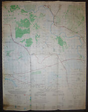
Ho Chi Minh Trail - Chiphu - Cambodia / Vietnam Border - Tay Ninh - Hieu Thien - Phuoc Ninh - Phu Khuong - Khiem Hanh - Khet Svay Rieng - Srok Rum Duol - Srok Svay Teap - Phuoc Luu - Highway 22 - Cam Giang Combat Base - Long Binh Combat Base (Tay Ninh) - Vam Co Dong River - Highway 1.An Thanh
An Thanh, situated in Tây Ninh Province near the Cambodian border, held critical strategic importance during the Vietnam War as it lay along the Ho Chi Minh Trail. This trail served as a vital supply route for North Vietnamese forces, facilitating the movement of troops, equipment, and supplies from North Vietnam through Laos and Cambodia into South Vietnam. In 1971, An Thanh was captured and contested by Viet Cong (VC) forces, highlighting its role in guerrilla warfare tactics aimed at disrupting South Vietnamese and U.S. military operations. The area witnessed significant combat, including airstrikes and ground assaults, as both sides sought to control this key logistical route. Cam Giang Special Forces Base
The Cam Giang Special Forces base, located in Tây Ninh Province, Vietnam, was a critical military installation during the Vietnam War. Situated near the Cambodian border, it served as a strategic outpost for U.S. Special Forces and South Vietnamese troops. The base played a pivotal role in conducting counterinsurgency operations, including reconnaissance, ambushes, and intelligence gathering. Its proximity to infiltration routes and border regions made it essential for efforts to disrupt enemy supply lines and monitor movements. Cam Giang Special Forces base was integral to the broader military strategy in the area, aiming to maintain security and combat insurgent activities during the conflict.
Chiphu
Chipho (or Chiphu) was a critical region in Cambodia during the Vietnam War, strategically located near the border with South Vietnam. This area became significant as a supply route and sanctuary for North Vietnamese forces, Viet Cong, and Khmer Rouge fighters seeking refuge and logistical support away from the direct combat zones of South Vietnam.
Chipho served as a vital segment of the Ho Chi Minh Trail, a network of trails and roads used by North Vietnamese forces to transport troops, weapons, and supplies from North Vietnam through Laos and Cambodia into South Vietnam. This route allowed the North Vietnamese Army to sustain its operations and support the Viet Cong insurgency against South Vietnamese and U.S. forces. The region provided a safe haven for communist forces, allowing them to regroup, train, and launch attacks into South Vietnam. The dense jungle and mountainous terrain of Chipho provided natural cover and made it difficult for allied forces to conduct effective operations against entrenched enemy positions.
In response to the use of Cambodian territory by North Vietnamese forces, the United States conducted extensive bombing campaigns in Chipho and other parts of Cambodia. These operations, such as Operation Menu and Operation Freedom Deal, aimed to disrupt enemy supply lines and reduce their ability to operate freely in the region. Throughout the war, there were several incursions and cross-border operations into Cambodia by U.S. and South Vietnamese forces. These operations sought to interdict supply routes, destroy enemy bases, and capture or neutralize enemy forces operating from Cambodian territory.
Chipho\'s role in the Vietnam War was significant but controversial due to the involvement of Cambodian territory in a conflict that had primarily been associated with Vietnam. The war\'s impact on Cambodia was profound, contributing to destabilization and laying the groundwork for the rise of the Khmer Rouge regime, which came to power in 1975.
Vietnam War MAP
- Measures - 29 x 22.5 inches ( 74 x 59 cms )
- Series L 7014
MAP Series – L7014
The 1:50,000topographic map series L7014, produced by the U.S. Army during the Vietnam War,provided detailed geographical information essential for military operations.These maps were created using aerial photography and field surveys, offering acomprehensive view of specific areas in Vietnam.
With a scale of1:50,000, these maps depicted one centimeter on the map as equivalent to 500meters on the ground (or 1,000 meters per grid), allowing for precise locationreferencing and detailed representation of the terrain. The maps includedcontour lines to show elevation and terrain features such as hills, valleys,and mountains. Hydrography was detailed with rivers, streams, lakes, and otherbodies of water clearly marked, while different types of vegetation cover, suchas forests, grasslands, and agricultural areas, were also indicated.
Man-made features wereextensively detailed, including various types of roads from major highways tosmall trails, railways, bridges, and ferries. Locations of towns, villages, andcities were marked, providing a clear view of built-up areas. Military installations,such as bases, airfields, and defensive structures, were identified, along withany notable strategic points like supply depots, command centers, andcommunication hubs.
During the VietnamWar, these maps were crucial for planning and conducting military operations,enabling commanders to understand the terrain, plan routes, and locate enemypositions. The detailed topography and man-made features facilitated navigationand tactical planning.
Today, these maps arevaluable for historical research, offering insights into the geography andlogistics of military operations during the Vietnam War. They are also ofinterest to military collectors, veterans and their families, helping themlocate specific places of personal significance from the war.
Related Items:
6231 iii - AN THANH, Map - HCM Trail 1971 - Chiphu, Cambodia Border, Vietnam War
$240.00
![[UNOPENED in BOX] figma 563 Shin Megami Tensei III Hitoshiura Figure #6231 picture](/store/img/g/VDwAAOSwrgRmd-Qh/s-l225/-UNOPENED-in-BOX-figma-563-Shin-Megami-Tensei-III-.jpg)
[UNOPENED in BOX] figma 563 Shin Megami Tensei III Hitoshiura Figure #6231
$175.99
New Idea 6230/6231Three Row Forage Harvester Dealer's Part Book
$12.99