
Original 1890 Antique Map ARIZONA NEW MEXICO Alamogordo Farmington Tucson Tempe For Sale

When you click on links to various merchants on this site and make a purchase, this can result in this site earning a commission. Affiliate programs and affiliations include, but are not limited to, the eBay Partner Network.

Original 1890 Antique Map ARIZONA NEW MEXICO Alamogordo Farmington Tucson Tempe:
$33.50
Original 134-year-old Antique Map of Arizona and New Mexico Drawn & Engraved by E.F. Fisk for the 1890 Edition of The People's Cyclopedia of Universal Knowledge: A Compendium of Invaluable Reference in all Departments of the Arts and Life; Illustrated with More than Five Thousand Engravings and Over One Hundred Color Maps of Each State, Principal City, and Territory of the United States, Continents, and Countries Across the Globe. Intricate Detail of County Boundaries, Cities, Towns, Railroads, along with Rivers, Lakes, and other Natural Landmarks. Fine Map for the Collector or Historian. Great for American History and Family Genealogy. Makes an Imaginative and Creative Gift. Easily Framed. Original Map Drawn & Engraved by L.B. Folger for the 1890 Edition of The People's Cyclopedia of Universal Knowledge: A Compendium of Invaluable Reference in all Departments of the Arts and Life, the Whole Brought Down to the year 1890, with Pronunciation Conformed to Webster's Unabridged Dictionary, Illustrated with More than Five Thousand Engravings and Over One Hundred Color Maps of Each State, Principal City, & Territory of the United States, Continents, and Countries Across the Globe.NOT A REPRODUCTION.Edited by W.H. De Puy, A.M., D.D. and Assisted by a Corps of Special Contributors, Including: Thomas A. Edison, Inventor of the Telephone & Phonograph; John Clark Ridpath, Author of The History of The United States of America; A.G. Haywood, President Emory College, Oxford, Georgia; William F. Warren, President Boston University;Joseph Alden, President New York State School, Albany; Thomas Summers, Professor Vanderbilt University; and William Wells, Professor Union College. Engraved by E.F. Fisk. Published 1890 by Hunt & Eaton; New York and San Francisco; a Copy of the Title Page of Which is Included. Intricate Detail of County Boundaries, Cities, Towns, Railroads, along with Rivers, Lakes, and other Natural Landmarks. United States 1880 Census Population of Each County listed on Reverse. Fine Map for the Collector or Historian. Great for American History & Genealogy. Easily Framed. Dimensions:10.5"x13.5" Map is inExcellent/Very Goodcondition. No writings, marks, or tears. Mild foxing. Single fold as Issued. A Few of the Cities, Towns, Counties, Railroads, and Landmarks Shown on the Map Include:ARIZONA:Tempe, Frankfort, Glasgow, Princeton, Calhoun, Morganfield, Warsaw, Danville, Lancaster, Harrodsburg, Bardstown, Flagstaff, Globe City, Florence, Phoenix, Holbrook, Brigham, Mineral Park, Colorado Plateau, Woodruff, Tombstone, Dragoon, Summit, Wowie, Benson, Copper Mine, Maricopa County, Indian Agency, Sweetwater, Nugget, Pueblo, Painted Rock, Casa Grande, Stanwix, Texas Hill, Yuma City, Cottonwood, Alexandria, Camp Reno, Camp Verde, Antelope Valley, Prescott, Townsend, Skull Valley, Winslow, Navajo Springs, Sanders, Leroux Crossing, Maryville, Smith's Mill, Tucson, Camp Grant, Hayden, Fort Apache, Eureka, Kirkland, Estrella, Tip Top Mine, Sentinel, and many others.NEW MEXICO:Los Lunas, Santa Fe, Cimarron, San Ysidro, San Augustine, Hot Springs, Alameda, Gallup, Defiance, San Juan, Water Hole, Lake Valley, Shakespeare, Watson, Porter, Rincon, Afton, Lanark, Sellers, Hatch, Richmond, Hudson Hot Springs, Old Fort West, Coleman, Fort McLane, Zuni, Salt Lake, Good Bend, Lloyd's Crossing, Lincoln, Fort Stanton, Fort Sumner, Roswell, Laguna, South Park, White Oaks, Cottonwood, Las Cruces, Georgetown, Silver City, Lone Mountain, Albuquerque, Tula Rosa, Socorro, Round Mountain, Upham, Las Vegas, Moro, Springer, Franklin, Apache, Santa Clara, Tiptonville, Volcano, Towner, Springer, Dante, Sweetwater, Farmington, and many others. (If you are Interested if a particular city, town, family, or landmark is shown, email the name & vicinity and I will look to see if it is included on the map.) Imaginative & Creative Gift. Some, to beautify their parlors, chambers, and studies . . . loveth, getteth, and useth, maps, charts, and geographical globes.
-John Dee, Advisor to Elizabeth I.
Related Items:
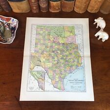
Original 1890 Antique Map TEXAS INDIAN TERRITORY Garland Waco Tyler Brownsville
$52.00
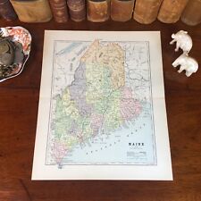
Original 1890 Antique Map MAINE Portland Lewiston Brewer Auburn Bangor Rockland
$26.80
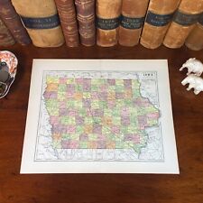
Original 1890 Antique Map IOWA Dubuque Council Bluffs Cedar Rapids Newton Boone
$26.80