
Original 1885 Antique Map IOWA Davenport Waterloo Sioux City Ankeny Cedar Rapids For Sale

When you click on links to various merchants on this site and make a purchase, this can result in this site earning a commission. Affiliate programs and affiliations include, but are not limited to, the eBay Partner Network.

Original 1885 Antique Map IOWA Davenport Waterloo Sioux City Ankeny Cedar Rapids:
$33.60
Original 139-year-old Antique Map of Iowa Drawn & Engraved by E.F. Fisk for the 1885 Edition of The People's Cyclopedia of Universal Knowledge: A Compendium of Invaluable Reference in all Departments of the Arts and Life; Illustrated with More than Five Thousand Engravings and Over One Hundred Color Maps of Each State, Principal City, and Territory of the United States, Continents, and Countries Across the Globe. Intricate Detail of County Boundaries, Cities, Towns, Railroads, along with Rivers, Lakes, and other Natural Landmarks. Fine Map for the Collector or Historian. Great for American History and Family Genealogy. Makes an Imaginative and Creative Gift. Easily Framed. Original Map Drawn & Engraved by E.F. Fisk for the 1885 Edition of The People's Cyclopedia of Universal Knowledge: A Compendium of Invaluable Reference in all Departments of the Arts and Life, the Whole Brought Down to the year 1885, with Pronunciation Conformed to Webster's Unabridged Dictionary, Illustrated with More than Five Thousand Engravings and Over One Hundred Color Maps of Each State, Principal City, & Territory of the United States, Continents, and Countries Across the Globe.NOT A REPRODUCTION.Edited by W.H. De Puy, A.M., D.D. and Assisted by a Corps of Special Contributors, Including: Thomas A. Edison, Inventor of the Telephone & Phonograph; John Clark Ridpath, Author of The History of The United States of America; A.G. Haywood, President Emory College, Oxford, Georgia; William F. Warren, President Boston University;Joseph Alden, President New York State School, Albany; Thomas Summers, Professor Vanderbilt University; and William Wells, Professor Union College. Engraved by E.F. Fisk. Published 1885 by Phillips & Hunt; New York and San Francisco, in Conjunction with Martin Garrison & Co., Boston and Toronto: 1885; a Copy of the Title Page of Which is Included. Intricate Detail of County Boundaries, Cities, Towns, Railroads, along with Rivers, Lakes, and other Natural Landmarks. United States 1880 Census Population of Each County listed on Reverse. Intricate Detail. Exceptional Color. Fine Map for the Collector or Historian.Great for American History & Genealogy.
Easily Framed. Dimensions:10.5"x13.5" Map is inExcellent/Very Goodcondition. No writings, marks, or tears. Mild foxing. Single fold as Issued. A Few of the Cities, Towns, Counties, Railroads, and Landmarks Shown on the Map Include:Des Moines, Cedar Falls, Waterloo, Charles City, Independence, Cedar Rapids, Lansing, Clinton, Muscatine, Washington, Fort Madison, Mediapolis, Columbus City, Vinton, Adel, Chariton, Ottumwa, Mt. Pleasant, Burlington, Iowa City, Dallas, Ft. Dodge, Tysons Mills, Homer, Clyde, Story City, Lisbon, Marion, Dubuque, Lowden, Ainsworth, Crawfordville, Newton, Toledo, Waverly, Boone, Montezuma, Wapello, Lone Tree, Pocahontas, Geneva, Faulkner, Coldwater, Seneca, Gowrie, Sioux Rapids, Sheldon, Mount Hope, Battle Creek, Albion, Coon Rapids, Atlantic, Red Oak, Franklin, Richmond, Raymond, Ossian, Bristol, Benson Grove, Rock Falls, Algona, Cerro Gordo County, Rockwell, Amsterdam, Ontario, Bloomington, Cornell, Monticello, Cottage Hill, Lyons, Delmar, Charlotte, Quincy, Decatur, Ashland, Fairfield, Chariton, Alton, Emerson, Malvern, Hamburg, Abingdon, Ozark, Clayton, West Dayton, Swede Point, Helena, Urbana, Auburn, Springdale, Danforth, Solon, Oxford, Monroe, Colfax, Dryden, Amish, Harper, Lancaster, Trenton, Winfield, Marshall, Augusta, Pulaski, Westerville, Hamlin, Avoca, Council Bluffs, Lenox, Conway, Riverton, Sidney, Edna, Lewis, Prairie City, Leighton, Sigourney, Hartford, Dale City, Breda, Storm Lake, Sheldon, Hartley, Sac City, Grant City, Howard, Faulkner, Clarence, New Hampton, South English, Libertyville, Norwood, Glidden, Rockwell City, Primghar, Orange City, Royal Ridge, Guthrie, Cambridge, Waverly, Mason City, Lowden, Rock Dale, Massey, Marengo, Woodbine, Plum Hollow, Union Hill, Tyrone, Red Rock, Boonsboro, Calhoun, Knoxville, Oskaloosa, Altoona, Liberty, Creston, Mapleton, Mt. Auburn, Douglas, Hampton, Horton, Concord, Irvington, Manchester, Greeley, Bradford, Garner, Fonda, Newell, Alta, Cherokee, Hazard, Defiance, Mineral Ridge, Fairbank, Decorah, Castalia, Troy Mills, Paris, Shell Rock, Clayton, Osage, Orchard, Mona, Greene, Eldora, Raton, Polk City, Clarinda, Riverton, Thayer, Allerton, Seymour, Moulton, Belknap, Ashland, Albia, Russell, Leon, Glenwood, Dyersville, Millville, Allison, Marble Rock, Rochester, Palo Alto County, Silver Creek, Echo, Discord, Melrose, Janesville, Denver, Chapin, Farley, Malcom, Flint, Jackson, Derby, Corning, and many others. (If you are Interested if a particular city, town, family, or landmark is shown, email the name & vicinity and I will look to see if it is included on the map.) Imaginative & Creative Gift.
Some, to beautify their parlors, chambers, and studies . . . loveth, getteth, and useth, maps, charts, and geographical globes.
-John Dee, Advisor to Elizabeth I.
Related Items:
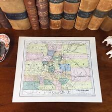
Original 1885 Antique Map COLORADO Boulder Pueblo Centennial Aurora Arvada Aspen
$33.60
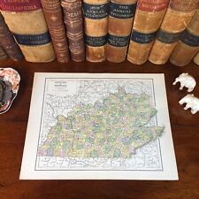
Original 1885 Antique Map KENTUCKY TENNESSEE Lexington Nashville Knoxville Berea
$33.60
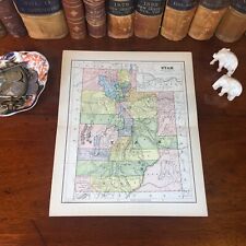
Original 1885 Antique Map UTAH West Valley Salt Lake City Jordan Orem Provo Lehi
$33.60