
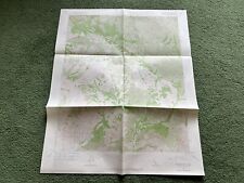
1959 US Northwest Jet Navigation Map Flight Chart Mlps San Francisco Seattle For Sale

When you click on links to various merchants on this site and make a purchase, this can result in this site earning a commission. Affiliate programs and affiliations include, but are not limited to, the eBay Partner Network.

1959 US Northwest Jet Navigation Map Flight Chart Mlps San Francisco Seattle:
$19.98
Description: This listing is for one flight chart printed by the U.S. Geodetic Survey. Northwest sectional aeronautical chart. Printed 1959. Measures very large at 55" x 35". Suitable for framing, but would also make great raw material for an art project like: scrap booking, shadow box background, mosaic, mixed media collage, etc... Also, these maps make an incredible wall mural if collect enough consecutive maps.
Condition: Very good condition. No damage. May have some hand written notes.
Shipping: Shipping in the continental US is free for USPS Ground Mail. I am happy to ship to all points international.
I have other aeronautical chart listings. Be sure to click on "See other items".
Related Items:
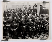
1959 US Marine Corp Officer Meeting Briefing Planning Vintage Military Photo
$12.50
Vintage 1959 US Dept Of Geological Survey Figueroa Mtn. CA Topographical Map
$24.95

Postcard United States Supreme Court 1959 US Capitol Vintage posted Alexandria
$11.99